
I started an on line embroidery course with Zara Day a few weeks ago on cartography, I love looking at maps and I’ve a couple of ideas rumbling round my head of embroidered maps, so hopefully this will give me a kick start.
I’m a little behind at the moment as the lessons are weekly and I’ve a lot going on at the moment at home but this week I’ve managed to do a bit of catching up. Each week we try a different way of embroidering maps, from stitching on the actual paper to hand-stitching contour lines. These are the ‘maps’ I’ve stitched in the first couple of weeks…


The third lesson was ideas for stitching contour lines, making more of a geological map than the road maps of the previous pieces. Most of us seem to be finding the most difficult bit of this course is finding a suitable map to the scale or detail we require, together with finding an area personal to us but with enough variety on it to be interesting to stitch.
Of course my first thought was Catbells, I’ve stitch this fell many times but always as an outline shape, rather than the contours of a map. I found an OS map on line which I could adjust to the size I wanted, rather than tracing the ones I have at home. I made my map slightly smaller, just so I could get the areas of interest on whilst not being too big and taking forever to stitch.
The four squares I chose included Catbells and Derwentwater. I decided to paint the background with silk paints. I added aloe vera gel as an experiment to see if it stopped the silk paint from spreading. It did, though it didn’t go on quite as smoothly as I would have liked.
I embroidered the main contour lines, on the map there’s another four fine ones in between each of these which would clearly have been too much on this scale. I used a single thread of DMC and back-stitch. I tried to keep as much as possible to the colours on an OS map, so the footpaths are in green running stitch, different stitch lengths denoting the size of the path. The road is in yellow and the route of the Derwentwater launches is in dark grey. I included the blue grid markings too which help to frame it whilst allowing the map to extend a bit further. To give you an idea of scale, the four boxes measure just under three inches.

I’m pretty pleased with this one as a practise piece.
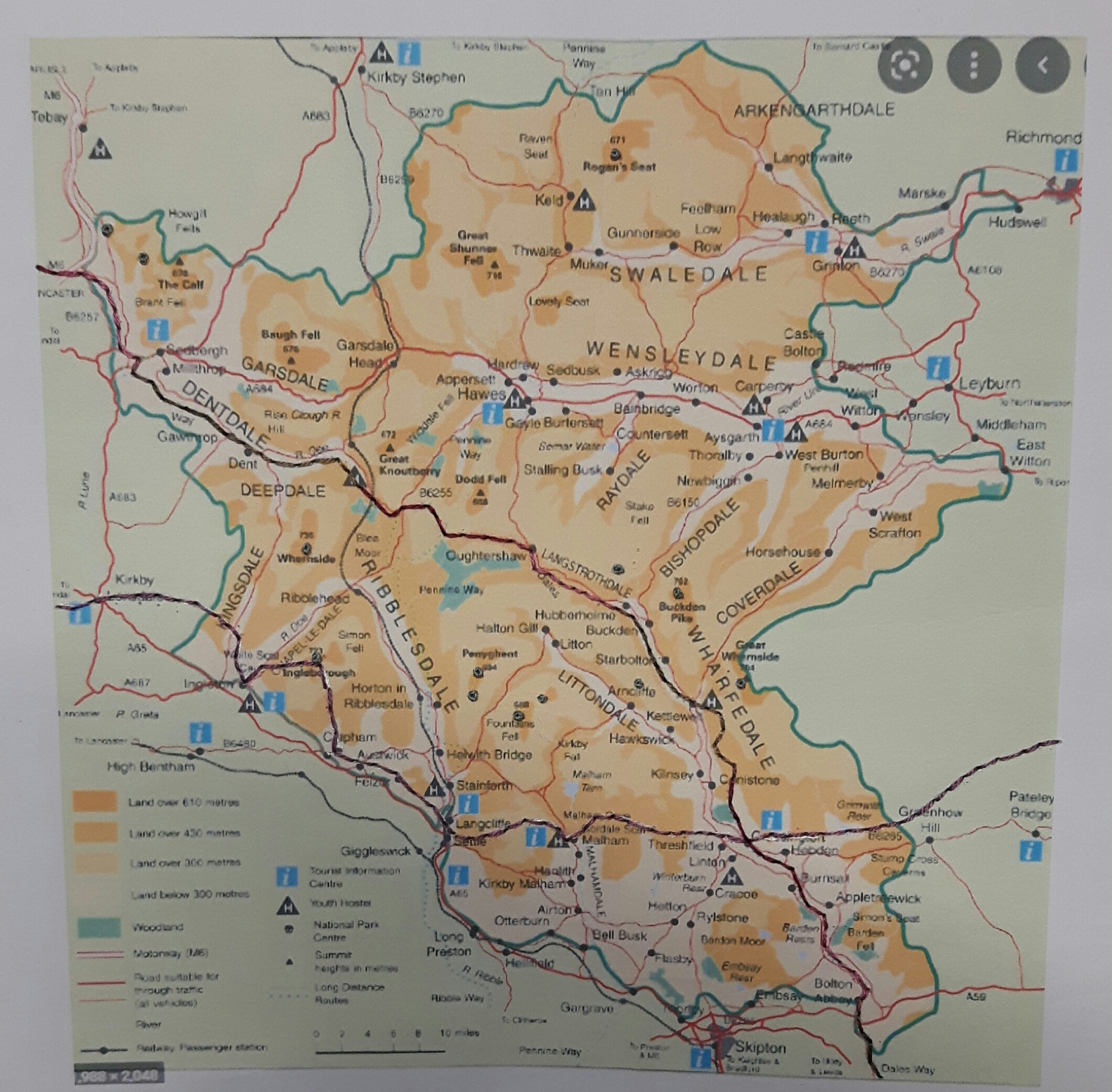
The next lesson was about using quilting to stitch a map. One idea I’ve had mulling about for a couple of years is to embroider a map of the Yorkshire Dales, with not just the main valleys such as Wharfedale, Wensleydale and Swaledale, but all the little side valleys such as Langstrothdale or Bishopdale. Whist my idea is for quite a big embroidery, I decided to do a mini version.
I found a map which showed the rivers and dales, I traced the rivers and then used a light box to transfer the tracing onto some calico. I didn’t want a plain calico background so I had a rummage in one of my stash boxes and found some lovely organza in shades of green and purple, perfect!
I sandwiched the fabrics together with some batting and a calico back and used free motion quilting to outline the rivers in a variegated blue thread. I went over the lines a second time to make them a bit heavier.
My original thought was that the quilting of the river courses would provide me with the valley and fell in relief, a sort of 3D map, however there just wasn’t enough stitching so I decided to do some ‘contour’ lines in green. Here artistic license took over, as I didn’t want to start trying to trace and transfer lots of contours…so I made them up! I like the effect of the organza and the quilting on this piece, it’s certainly given me food for thought when I finally get round to stitching the dales…
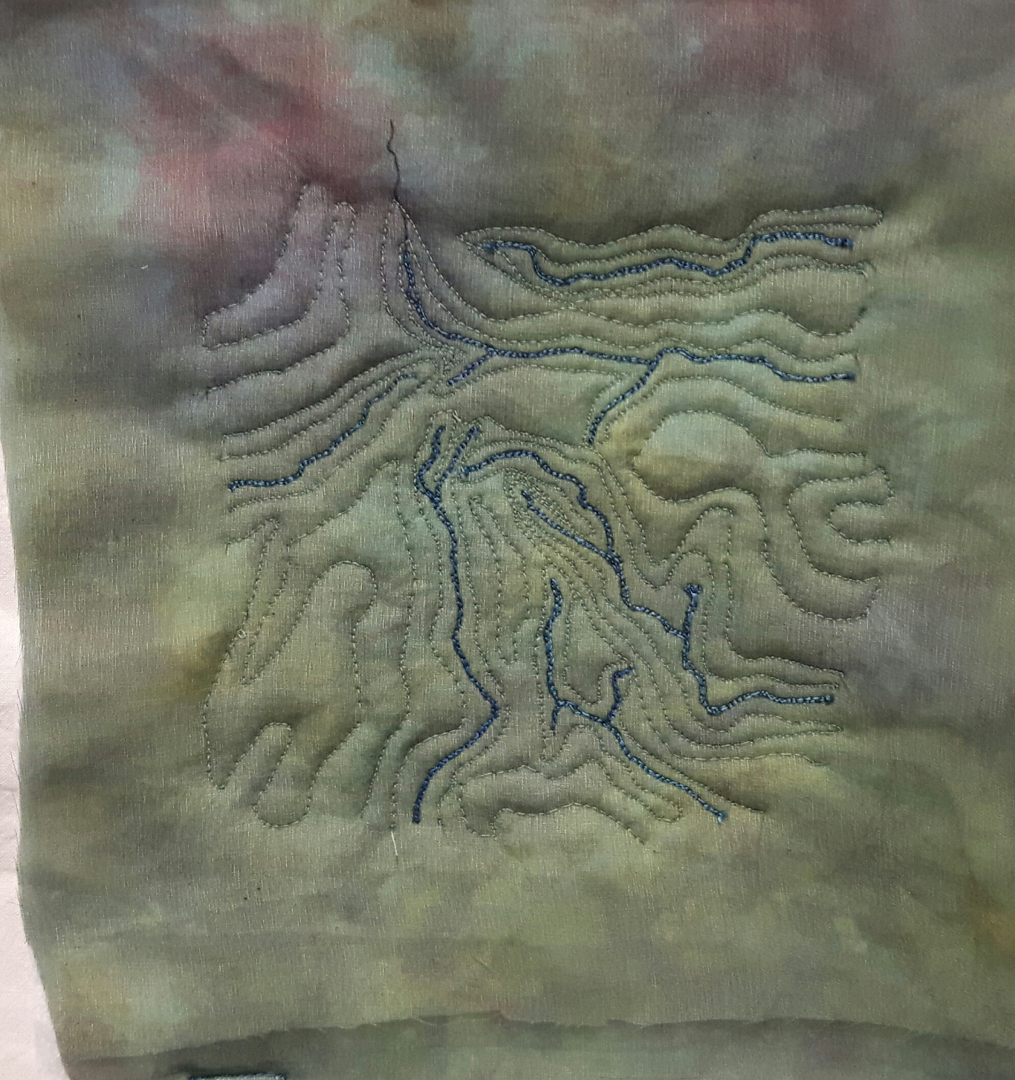
I learnt a little interesting fact a couple of weeks ago about the river Wharfe which runs through Otley. On my map it’s the one which goes from the middle to about 4 o’clock. It’s the fastest rising and fastest falling river in Europe apparently.
I haven’t quite decided what I’m going to do with these maps yet, maybe I’ll put them all together in a fabric atlas of my favourite places!


A fabric atlas is a great idea….and it will be a sampler of your ideas too. Your work, especially on these maps, always gives me a creative spurt!
LikeLiked by 1 person
That’s sew cool and a great idea
LikeLiked by 1 person
This is a fascinating project and your creations from the course are fantatic
LikeLiked by 1 person