
I’ve enrolled on a Zara Day Cartography Embroidery course, I’m way behind as usual but as Zara sends links for all the recordings which I can then save, it doesn’t matter how long I take! I’m just enjoying the journey!
In the first workshop we were stitching directly onto a map, I used a map of the Yorkshire Dales where I could plot my walks…

We had a second method to try from the first week too. This involved choosing an area and stitching areas so the map could be cut a way in places. Half the conundrums on doing this course is choosing a map…and I’m clearly not alone from the comments on Whatsapp! In the end I decided to do a map of West Witton.
West Witton is a village in Wensleydale where my mum had a cottage for many years, she was up there every weekend and school holidays too, she made lots of friends in the village and joined in village activities as much as she could. We had many holidays up there too especially when the children were small.
I found a map and laid it over some soft green fabric, not sure if it’s cotton or linen but it feel lovely. I tacked round the map to hold it securely. I started off using stem stitch for the main road through the middle and a slightly thinner stem stitch for the side roads and back lanes.
I liked the patterns of the fields on the map with the remnants of the old strip fields which go back centuries. Each cottage would have a strip of land behind it to grow vegetables or raise animals or chickens. I used back-stitch in grey thread for the walls. I then used a scalpel to very carefully cut away the paper so the fields were shown as green fabric.
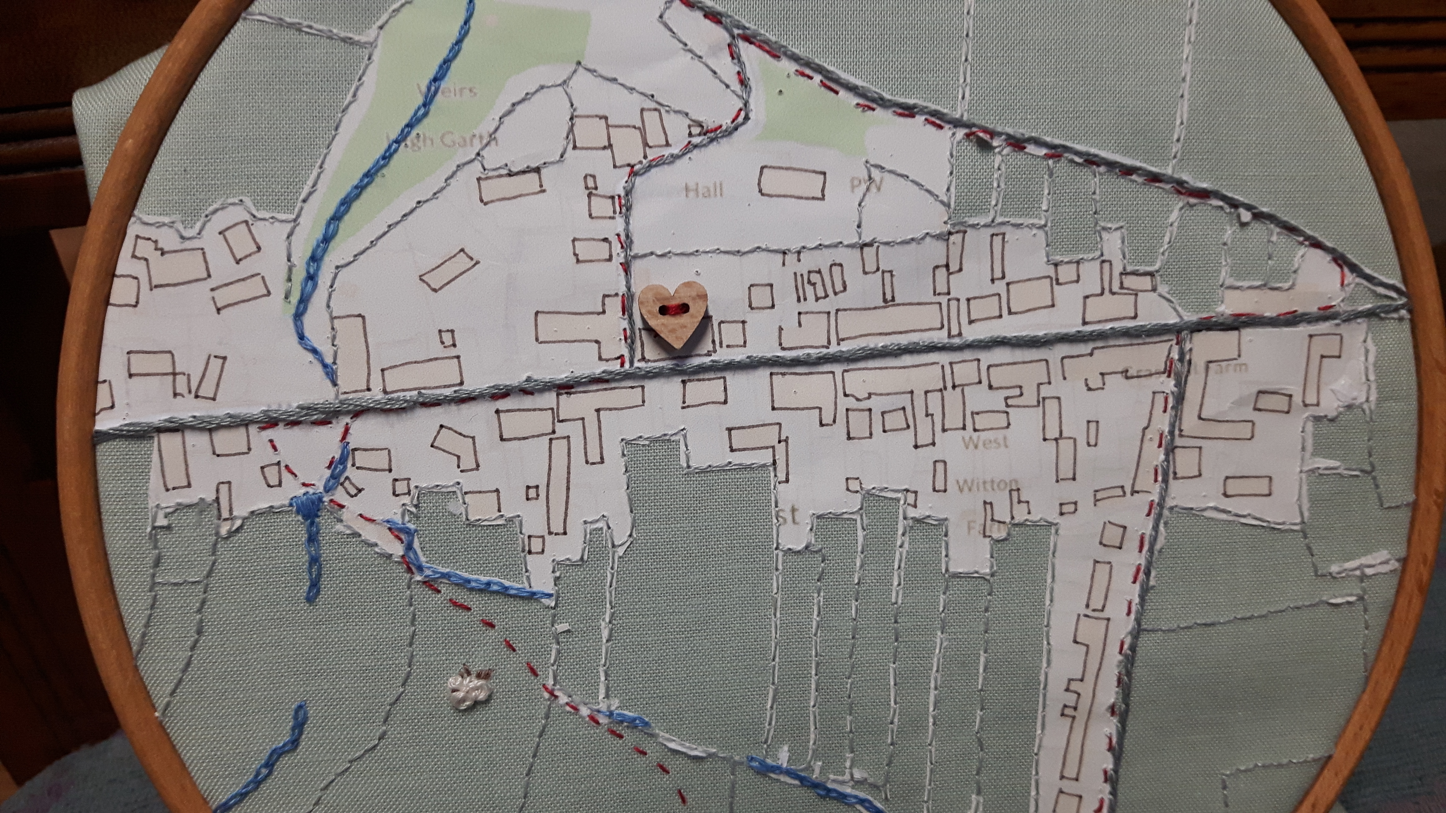
The blue chain stitch is used for the streams around the village. We used to often walk over the fields so the children could paddle in their wellies, the intermittent one shown at the bottom of the map is not much more than a rill in places but they would spend hours toddling up and down. I’ve found a photo, well it’s a photo of a photo of a photo, so excuse the quality!

I’ve stitched the footpaths in red and the heart shaped button is where my mums cottage was. The buildings weren’t very clear on the copy I made so I went over them with a sepia fine point pen.
The bunch of French knots by the lower footpath marks the spot where I rolled a rigged sheep, as a townie by birth I was pretty proud of myself! For those of you who are wondering what on earth a rigged sheep is…
In the spring when the fleeces are pretty thick the sheep can get top heavy especially after rain. If they overbalance they can’t get back up again and just lie stranded on their backs. Now sheep are a bit like chickens, one day you have a live healthy chicken, the next day it’s dead, or as a friend who’s a farmer once said to me, any excuse and a sheep will die! If they are left upside-down for any length of time they won’t survive, all you have to do is give them a push to roll them back over onto their feet. In Yorkshire this is known as riggwelter or a rigged sheep. Those of you in the UK will probably have heard of Black Sheep beer, it’s brewed in Masham, just down the road from the cottage. They have a beer called Riggwelter, it’s 5.9% so pretty strong for a beer (so I’m told!) and if you drink too much you’ll end up riggweltered!
Anyway, I gave the sheep a push and over it went and trotted off down the field.
So there’s lots of happy memories in this stitched map. I put it in a ring frame partly to reduce the amount of stitching and I think it looks pretty good.


Rigged sheep…riggweltered. I have never heard those terms, Margaret. Thanks so much for the education! 🙂
LikeLiked by 1 person
It’s an old Yorkshire term I think
LikeLiked by 1 person
I am quite fascinated by this, Margaret. Your map has a lovely simplicity. The lines stitched into the material balance out the shapes of the houses. I am looking forward to seeing more of your maps.
LikeLiked by 1 person
What a clever idea and lovely memento
LikeLiked by 1 person