
Last week my friend and I ticked off another of the Dales 30 challenge, we were hoping to do too but the weather conspired against us!
We were climbing Ingleborough but we were also hoping to do Simon Fell too, which is only a short distance away. We walked from Clapham which is probably the most scenic route up, there are several routes up Ingleborough and we’ve done most of them over the years but as the days are getting shorter we decided the nearest and clearest route was probably the best.
Clapham is a very pretty village, we parked up near the old church so it was just a short walk to the path through the Ingleborough Estate. It was a lovely walk up past the waterfalls and past the lake. They’ve put up some information boards since we were last up and we were interested to read that this area is totally manmade, the early owners of Ingleborough Hall built a dam across the narrow valley to form both the lake and the waterfalls below.

The lake was lovely and peaceful with the autumn colour gently reflected, unfortunately I didn’t get a photo as I was lulled into a false sense of security thinking I could get one on the way back!
At the far end of the lake is the entrance to Ingleborough Cave, this is open for tours during the summer, there’s a footpath which goes about 500m in, it’s full of stalactites and stalagmites.
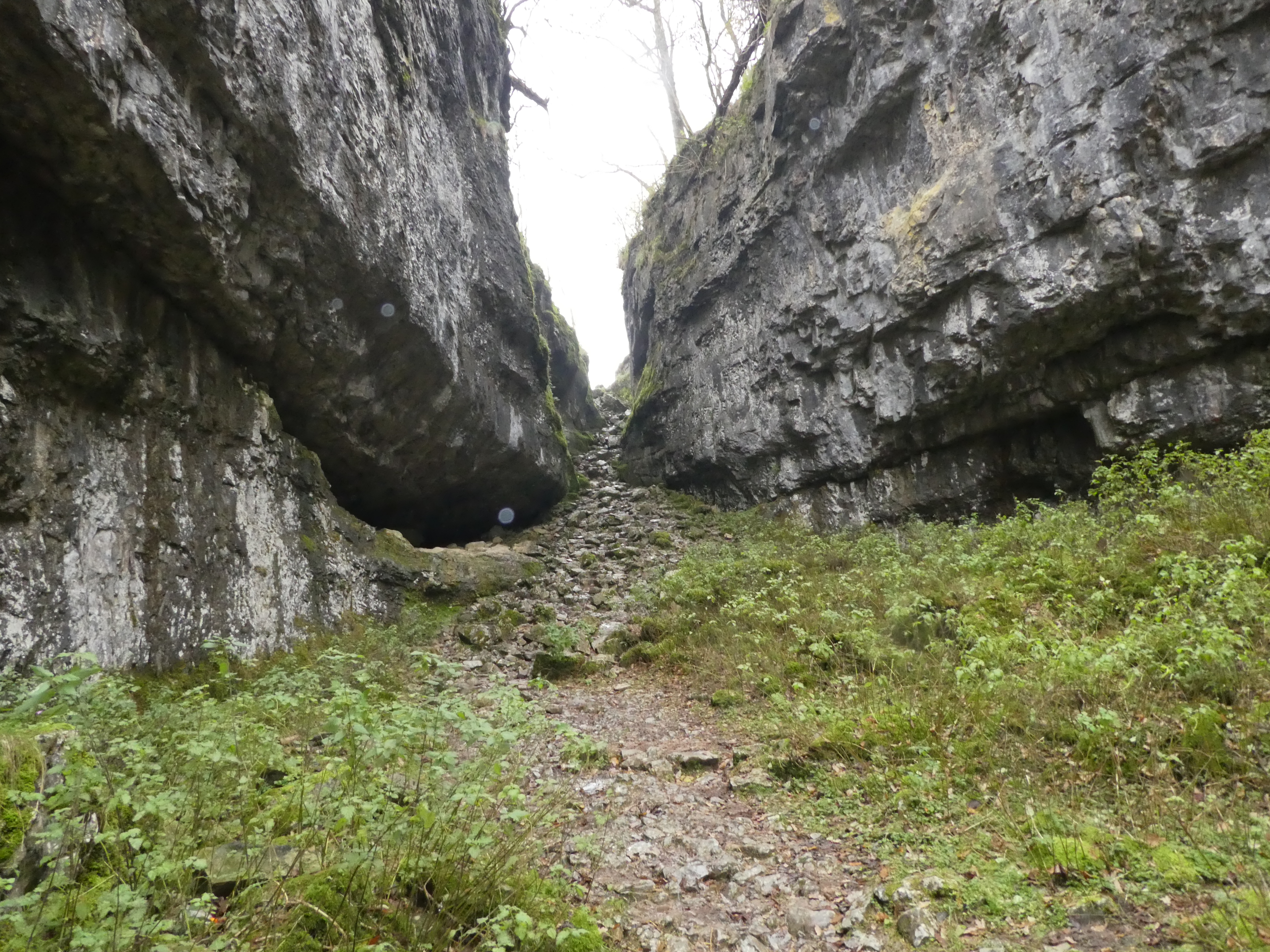
We carried on up towards Trow Gill, a steep gorge at the top of the valley. It’s a bit scrambly towards the top as you can see but we just took our time.
Trow Gill leads to the plateau before the final ascent of Ingleborough, the footpath passes close to Gaping Gill, this leads to a huge cavern, it’s so big you could fit York Minster in it. The local caving clubs organise trips down Gaping Gill a couple of times a year, you’re lowered down about 50′ or more on a bosuns chair one at a time, a few years ago I went down with friends and Helen, it was quite an experience. The stream that goes down Gaping Gill eventually comes out through Ingleborough Cave. Experienced cavers can trek through from Gaping Gill to Ingleborough cave, there’s a huge network of caves round there.

As you can see from the photo above, the mist had come down!! The higher we climbed the worse visibility got. The top of Ingleborough is quite a large, fairly flat plateau. Unfortunately it has about four paths leading off it is all directions and it’s very easy up there even in good weather to come off the wrong path and end up in the wrong valley.
According to the map there was a straight wall to follow from Ingleborough to Simon Fell, we were very dubious about whether we would be able to climb Simon’s Fell even before we reached the top of Ingleborough, it all depended on how clear the route by the wall was…

…that’ll be a no then!!
We couldn’t even see the dry stone wall seating area which marks the highest point! We had carefully taken a photo of one of the cairns we passed just before the top, so at least we would know we were on the right path down! Just as we reached the plateau there was a length of broken down wall, we sat on it and ate our sandwiches as we didn’t dare leave it and risk losing our sense of direction!
We saw two ladies trying to find a path down, they looked rather unsure so I called over to ask them which path they were looking for, they showed me a very simplified map on the mobile phone! I opened my OS map up and showed them where the other path went, we strongly advised them to stick to the clear (and popular) path down to Clapham rather than risk trying to find the quieter Pennine bridleway in poor weather especially without a proper map. It still amazes me that people will risk going walking in this kind of terrain without a proper map, signals fail, phones go dead, but also you can’t see the bigger picture to confirm where you are or which way to go. OS maps have walls, cairns, potholes, barns, lots of landscape features which all help to confirm where you are.
We retraced our steps to the path down to Clapham, at this point the weather was wind and rain, not the best weather for a walk, so it was head down and keep walking. Once we dropped down through Trow Gill again it was better, just a bit mizzly. It had improved enough by Ingleborough cave to sit on the seats for a welcome coffee and a sticky bun.
Altogether we walked nearly nine miles, we enjoyed ourselves despite the weather – if you walk in November in this country fine weather is a bonus! I think this will be the last of the Dales 30 this year as the days are getting too short for us slow walkers, we’ll do shorter more local walks over the winter and resume our challenge in the spring. We’ve walked eleven of the thirty, so over a third done, not a bad start!


Such lovely photos! Thanks for sharing them–even stormy weather looks so very beautiful there.
LikeLiked by 1 person
Nine miles – impressive! Wonderful landscapes, enjoyed the photos!
LikeLiked by 1 person
Such a beautiful place for your challenges. I live in not such exciting places and still take a real map. Just a nicer sense of being. I don’t mind walking in drizzle and cold, makes the getting home in front of the fire with a good soup all the more worth it.
LikeLiked by 1 person
It looks wonderful… I miss OS maps, they’re unknown here, and so much of the country is still uncharted to a great extent. Google Maps is helpful, but there’s nothing quite like a paper map, is there?
LikeLiked by 1 person
I love proper maps, I can spend hours looking at them and it’s very satisfying working out exactly where you are by looking at all the features. We were once walking in the Lakes and the path seemed to be going on and on, I noticed a distinctive field shape we were passing and was therefore able to pinpoint exactly where we were – not as far on as we hoped!
LikeLiked by 1 person
Thank you for taking me along on your walk 🙂
LikeLiked by 1 person
What a grand day you two had, mist, rain & all! And so kind and fortunate you spotted those 2 hiking without proper information. Margaret, please remind me what OS stands for (something Surveillance?) I know they’re detailed with all sorts of markings Don’t know if hikers over here have them, but it certainly make sense to me to have one! Gorgeous photos – thank you!
LikeLiked by 1 person
Hi, OS stands for Ordnance Survey, they are like the official maps in UK, the ones most commonly used by walkers are 2.5 inches to a mile, so you get lots of detail, like stone walls, barns, little woods, footpaths of varying size. I can spend hours looking at an OS map 🙂
LikeLiked by 1 person
Thank you, Margaret! I had the idea of what the maps contain, but couldn’t remember the proper name. I could probably pour over one for a while, too, once I got an understanding of all the symbols. Must be fascinating to use one whilst hiking, particularly when visibility isn’t good.
LikeLike
The photos are quite spectacular with the weather moving in. These walks are always an adventure for you, especially in the fall. I am impressed that you are 1/3 of the way to reaching your goal!
LikeLiked by 1 person
Nine miles is a great walk especially given the weather. It still surprises me that people rely on mobile phones for their map! You are making great strides (excuse the pun) into your challenge
LikeLiked by 1 person